Terrain
 left click [long click]
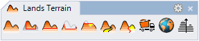
Lands Design terrains are topographic meshes created by lifting a surface from 3D curves, contour lines or point clouds.
Insert a terrain
After running the laTerrain command, the Terrain insert dialog box will appear. This dialog shows the basic options of the Terrain object in two tabs.
Steps:
- Select the rest of the terrain insert parameters and click OK to close the dialog.
- Select the terrain Input data, which can be either curves or points. Click ENTER to end the command.
The terrain object will be generated in the model.
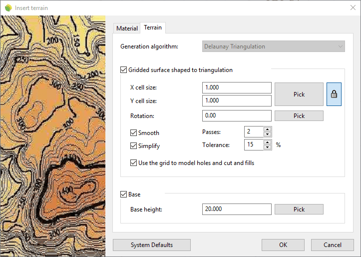
Insert dialog box for the Terrain object
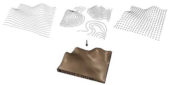
Terrains can be generated from different types of input data
Control points 
Terrains have the same control points as the curves used to generate them, and the curves used to do operations on terrains ( such as the Terrain Add Hole command, the Terrain Add Cut and Fill command, etc.). In addition, a Move control arrow appears next to each one of those curves, in order to move the whole curve.
Terrain control points are automatically enabled when selecting terrains one by one, as long as the total number of control points are not higher than 100. To turn one ore more terrain object control points on just select the terrain and run the PointsOn command (or press F10). To turn the points off, press the ESC button or run the PointsOff command.
The control points of geometry used to generate the terrain can be enabled or disabled individually from the Input data tab, in the Properties area of the Edit panel.
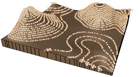
Control points on terrains
Insert options and parameters
The Terrain insert options and parameters are divided in different tabs, and are available from different dialogs:
- Terrain insert dialog box (only available when inserting new terrains).
- Terrain properties section, in the Lands Design Edit panel.
- Object Properties dialog.
- Properties Explorer dialog.
General
General attributes for the Terrain object: Name, Color, Layer, and Transparency (only visible in Conceptual display mode).
Terrain
Generation: Lands Design uses the Delaunay triangulation method to generate terrains. It is a popular terrain generation algorithm based on the optimum triangulation with the points that have a known elevation value.
Terrains can either be created using the triangulation faces directly or adjusting a grid to the form obtained after the triangulation process, with the purpose of obtaining a smooth surface.
Gridded surface shaped to triangulation: When this option is enabled, you can control the following parameters:
- Cell size
- Rotation
- Smooth
- Simplify
- Use the grid model to model holes and cut and fills
Base height: thickness of terrain base, taken from the lowest elevation data. When this option is unchecked the terrain is generated as an open mesh.
Input data
This tab is divided in two areas. The left area displays the list of input data (curves or points) used to generate the terrain and the operations applied to modify the terrain. The right area displays the parameters available for each selection.
Each curve or operation can be selected and removed from the list individually, and the terrain will be recalculated.
Contour lines
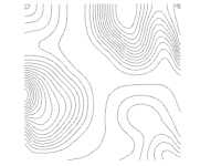
Contour interval: there are two options available to generate the terrain contour curves, for its 2D representation:
- Number of contours: divides the terrain height into a fixed number of contours.
- Distance between contours: creates terrain contours every certain distance among them.
Appearance: 2D display settings for the terrain contour curves. You can define indexed contours every "X" number of contours, add texts and assign them different line properties.
Material
This tab lets you change the textured image assigned to this element and define the image size, reflectivity and transparency.
Edit options
These are the edit options for the Terrain object, available in the Edit area of the Edit panel:
 Update
 Convert to 2D. Displays the object in 2D representation.
 Convert to 3D. Displays the object in 3D representation.
- Show 2D and 3D: Turns the object 2D and 3D representation on simultaneously.
- Copy properties from another object
- Extract curves
- Adjust
- Terrain
 Pick boundary
 Remove boundary. (This command only appears when a new boundary has been added to the terrain)
 Add contour curve
 Add hole
 Add cut and fill
 Add path
 Divide
 Volume of earthmoving
All commands to generate, edit and do operations on terrains can be found in the Lands Terrain toolbar.
Lands Design Terrain toolbar
Terrain graphical display
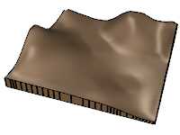
Lands Design offers different simultaneous 2D and 3D displays of Terrains on the drawing. The number of contour lines in the 2D display depends on the Contour lines settings.
|
|
| Terrain 2D display | Terrain 3D display |