Terrain Add Cut and Fill
 left click
This command generates cut and fills in the terrain from a closed curve. A cut and fill is an earthwork over the terrain, with the purpose of creating an embankment or a similar structure. A required slope angle will determine the quantity of soil removed from the top part of the cut and fills and the quantity of soil added to the lower part.
This operation also adds a division to the terrain from the same closed curve, as if you were using the laTerrainDivide command.
Steps:
- Pick a terrain. Press Enter or do right click when done.
- Specify an angle for the slope within the interval (0 to 90 degrees).
- Select a closed curve to define the cut and fill area. The curve can be placed in any position and orientation.
The terrain will add and remove the soil volume required to match with the curve position, according to the given slope angle.

Terrain before the Cut and Fill operation
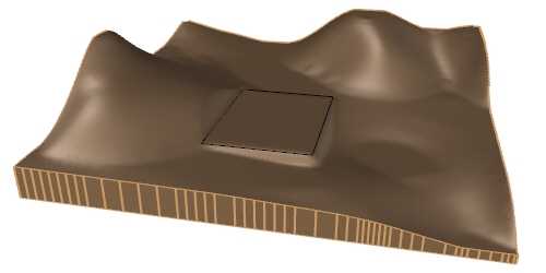
Terrain after the Cut and Fill operation
Parameters
The add cut and fill parameters can be edited from the Input data tab, (in the Properties area of the Edit panel or Properties Explorer dialog), under the Earthmoving list.
- Control points: option to enable or disable the control points of the cut and fill (and subdivision) area.
- Slope angle: angle by which the terrain will fit around the cut and fill boundary.
The edit options and parameters of the terrain subdivision generated by this command are the same as those generated with the laTerrainDivide command.
Control points 
The control points of the cut and fill area are the same as those of the curves used for this operation. They are integrated into the terrain and are visible when activating the terrain control points. They let you modify the contour of the cut and fill and the subdivision area.
They can be disabled from the Input data tab, (in the Properties area of the Edit panel or Properties Explorer dialog), after selecting the cut and fill under the Earthmoving list.
NoteThe control points of the subdivision created by a cut and fill depend on the cut and fill control points, regardless whether they are enabled or not in the subdivision settings.